Showing posts with label Google Maps. Show all posts

Thursday, May 29, 2008

Beijing map

Since the Beijing 2008 Olympic Games are approaching, I think it would be of general interest to have maps of Chinese cities available to people travelling to China.


Google Maps does not provide maps of Chinese cities on its international version. Only some roads are shown on their maps. They have another different server (DITU) to provide maps of Chinese cities, but this server does not show the satellite imagery.


So, I am working on a mashup to combine satellite imagery from Google Maps and the maps provided by Google Ditu. The final result is shown in this Beijing Map mashup.

UPDATE (2008/06/01): There is an improved version of the Beijing Map using a modified GMercatorProjection object. Now the markers on the map can be managed just as they are in standard maps. You can still have a look at the first prototype of the Beijing Map, just if you are interested. The original link has been changed to the last version of the map.

Tuesday, May 27, 2008

Google Maps: Geocoder

Looking for a geocoder?

I have been doing some tests with the Google Maps API. The intention is to start a series of articles covering different topics related to maps, geopositioning and cartography.


The first one is a general purpose geocoder. The geocoder allows you to obtain the coordinates of a point, either given its address or because you know its position on the map.


Hope you will find this topic of interest.

Wednesday, November 01, 2006

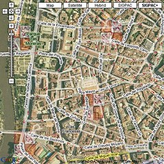
Google Maps + SIGPAC: Spain in high definition

Interesting development carried on based on two very useful products. By the combination of each one's advantages, the result is a product that avoids the limitations of each separate one.

On one side, Google Maps: The well known application offering satellite images (among other features) of the whole planet. This product has a nice interface very easy to use. Its only limitation, the areas in some countries (in this case, Spain) still not available as high resolution imagery.

On the other side, SIGPAC, the geographical information system from the Spanish Ministerio de Agricultura, Pesca y Alimentación. This application is publicly available, and it allows viewing ortophotos of the whole country in high detail level. The main drawbacks, are the images being a bit aged and a user interface suffering from some limitations.


The solution: just to combine the best of the two systems. Let the Google Maps interface use the SIGPAC maps when viewing areas not available in high detail level, and to continue using the original Google Maps imagery when available in high detail.

Best of all, is that even using external maps (such as the SIGPAC ones), we can still combine the additional information coming from Google Maps. This way, we can see street and route maps properly placed all over the SIGPAC images.

Here, you can view the mix Google Maps + SIGPAC

Spanish version of this story here